A trip through Xayaboury

Some images and notes from a recent trip through Xayaboury, the only province in Laos on the right bank of the Mekong river. Or if you want to be precise the only province completely on the right bank, as Bokeo, Luang Prabang and Champassak have small parts of their territory on that side of the river too.

These impressions are not in any way coherent. Chronology is the only order here. Travel is often a chain of unrelated experiences and events, arbitrary like life itself.

For geographical clarity at least, there is a map at the bottom.

I expected Thai influences in Xanakham, as Thailand is right across the river. But its pace and vibe, its stage of development, its few guesthouses and eateries, the attitude of its people were all completely Lao.

The waters of the Mekong were blue-green and clear. No good. They are supposed to be brown and turbid. The dam upstream near Xayaboury town must be to blame, blocking the sand and clay particles that turn the river muddy, and farmlands downstream fertile.

Paklay has grown over the past decade. More people. More prosperity. More dust and dirt. The bridge across the Mekong opened in July 2017. The Netherlands contributed 2.3 million euro to its construction, roughly 12 percent of the total cost. (Source Vientiane Times of July 5, 2017.) I guess it is a coincidence, but it has the retro look of Dutch pre- or post-WW2 bridges.

In Paklay too the Mekong changed colour. See its muddy waters on these January 2015 photos. The dam upstream wasn’t finished. The bridge was under construction.

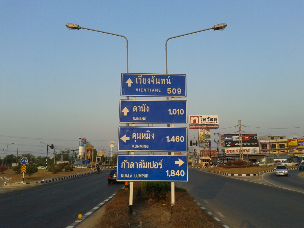
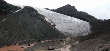
Paklay and the Mekong river in February 2023:

Thongmixay, inland, was a calmer, cooler, cleaner village than Paklay. From there it was a two hour walk to a small border post. Now and then a tractor or motorbike overtook me, and I was offered a ride. When they came from the other side they were laden with Thai imports. I didn’t expect to get to the market just across the border. And I was right. Laotian officers stopped me at their checkpoint, only local people were allowed to cross. Those that do enter Laos here are greeted by a martial monument, not befitting the Lao people who mostly prefer to avoid conflict and work their way around differences. In case you wonder about the top bar of the flag: yes, they must have run out of red paint.

Those that enter Laos here can also tell they are in the country from the crates of Beer Lao. They abounded in Thongmixay, as they do everywhere else in the country. A photo project on these bursts of yellow along Laos’s road sides would make for striking colour palettes and still lifes, and bizarre contexts, and special backdrops.

The most beautiful image passed by in a flash, a single crate in the middle of the road, the familiar bright yellow with a single branch of bright red bougainville sticking up. It was there to slow traffic for the wedding further up the road. No chance to take a picture from the driving bus. Travel is life itself, it doesn’t allow more than a short glimpse of its most amazing moments.

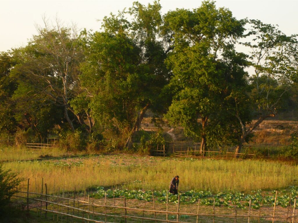
The area upstream from Paklay was full of village life, rural life, river life.

I stayed in Xayaboury for a couple of days, ran into a friend, wandered around town, strolled around the market, walked along the river, sat in a temple. Same routine everywhere I went this trip. I didn’t take photos. But that was my lack of inspiriation, the town was not to blame.

Xianghone and Xianglom are two halves of the same town, a thirty minute walk apart. Xianghone is the more spread out, with businesses, warehouses, a gas station, the bus station, guesthouses. At the edge of town is an unpaved wartime airstrip, now long out of use. As it is elevated, water gathers in pools next to it. Local people take advantage. The distant mountain range forms the border with Thailand’s Nan province. It also forms the divide between the Mekong and Chaophaya river basins. All rain this side flows into the Mekong, rain at the other side flows into the Nan river and subsequently into central Thailand’s main river the Chaophaya.

Xianglom is smaller and more rural than Xianghone. It feels more original, with two temples boasting age-old trees. Hidden in the forest nearby is a third one, with a cave, and bat smell, and encroaching plants and trees.

In Muang Khop Buddha watches over the town and valley from high up on a hill.

These two photos were taken at exactly the same spot, but in opposite directions. Buddha said introspection is a good thing. This gets misinterpreted in the selfie-age.

Muang Khop was a green oasis in this dry season, the only place where rice grew. Life seemed idyllic for the children in town. But less so for those staying at the boarding school, mostly ethnic Hmong from the border town of Ban Pangmon twenty kilometers away. The fourteen, fifteen year olds cooked their own food, and that of their younger school mates, in these sheds.

There were still traditional Hmong houses in Ban Pangmon, recognizable because they are built directly on the ground unlike the houses of almost all other ethnic groups in Laos that rest on stilts. These seasonal yellow flowers I saw all through the province. Recently harvested drying cassave was everywhere too, producing an unpleasant sour smell.

From Muang Khop (literally ‘district Khop’) I followed the Nam Khop (literally ‘river Khop’) to Pak Khop (literally ‘river mouth of the Khop’). Pak Khop village had an old temple with somehow naive and moving touches. Just my impression of course.

Near Konteun another Mekong ferry is being replaced by a bridge.

Near Konteun too, a road sign told me I had left the province of Xayaboury. It was the end of this trip.

You can trace my route through Xayaboury on this map, made as always by cartographer Jaap Vinke.

Between Nakhon Sawan and Luang Prabang

[This is the third and final post about my commutes between my favourite flight hub of Bangkok and my pied à terre in Luang Prabang. The others are Train no. 211 from Bangkok and (My) life in Nakhon Sawan. They’re memories of travels impossible and places unreachable in Covid-times.]

From Nakhon Sawan it’s a boring bus ride to Phitsanulok. I often passed through the city starting out as a tour leader in Thailand in the 1990’s, and enjoyed visits to the Buddha Casting Foundry with its traditional production methods. These days I don’t get into town, just stay overnight across the road from the bus terminal east of the city, where there is one of those clean and bright no-frills hotels  found in Thai provincial towns. The family that runs it is none too outgoing. But there is always a nod of recognition, or an ’it’s-been-a-while’ .

Nearby at an intersection is this sign:

Now this is a bit grand. No car or truck from Malaysia, China or Vietnam ever passes by. But Phitsanulok is a major domestic traffic hub. Straight west the road leads to the Myanmar border at Mae Sot, straight east to the Lao border at Mukdahan. Buses run south to Bangkok and north to each and all of the northern provinces.

Beyond Phitsanulok there are several possible routes to Luang Prabang, shown on the map below. I usually continue to Loei, and move on to Luang Prabang the next day. It is fastest and, well, cheapest.

But the route through Nan province also makes for interesting travel. This goes: bus from Phitsanulok to Nan; minivan to the Thai-Lao border at Moeng Nguen; a walk through no-man’s-land; finding some or other vehicle to Pakbeng on the Mekong; a boat down river to Luang Prabang.

I haven’t yet traveled the Uttaradit – Paklay stretch myself. Bucket list!

Text continues below map.

A geographical appendix

Each of these routes at some point must cross the divide between the Mekong and Chao Phraya basins. Interested in everything Mekong I try to figure out where exactly this divide runs, both by trying to work out the lie of the land while on the road, and by studying the unsurpassed Google Earth and following streams and rivers on its satellite images.

(Incidentally: how great an escape is Google Earth in times of lockdown. It allows me virtual travel, transports me to faraway places I’d rather be.)

It must be then that the Thai-Lao border follows the Mekong-Chao Phraya divide in the north of Thailand’s Nan Province, and the east of its Uttaradit Province.

The divide must run inside Thailand between the towns of Phitsanulok and Loei. But while traveling there, it is difficult to determine its course as there are several longer climbs and descends along the way. Google Earth also doesn’t provide a clear answer, so in this case the marking on the map is just an educated guess.

You may also be interested in an older post, describing my commutes from Luang Prabang to Bangkok in the opposite direction:

https://pieterblog.rdeman.nl/?p=185

2014 Preview

Hi to all!

Wishing you a happy and healthy new year.

My plans?

Awaiting publication of an article I wrote for Japanese Alpine News, detailing why I believe the new Mekong source I discovered last July together with Luciano Lepre has to be considered the river’s true source. What will reactions be?

I first introduced this source in a couple of blogs that you can find elsewhere on this page, posted between August 12 and 28, 2013.

Trips I am planning later in 2014:

In July will set out on a great China road trip. This will diagonally cut through China from the southwest (China/Laos border post at Mohan) to the northeast (China’s northernmost county of Mohe on the Russian border). Four weeks and 6,000 kilometers or so. From subtropical to Siberian latitude, crossing China’s main rivers: the Yangtze in the south, the Yellow River in the north. Public transport: battered mid-size buses, modern touring car models, the occasional high speed train. Always among the Chinese people – those still poor, those of the new middle class, those now rich. Small villages, huge cities. No better way to experience China.

Yunnan – Myanmar border trip

Will roughly follow this border, staying on the Chinese side. Starting in the south in the lands of the Wa – my current favorite tribe. Headhunters as late as the 1960’s they are now the kindest and most welcoming of people. Among other ethnic groups will be the Kachin, called Jingpo in China.

Of course there is the semi-independent (?) Wa State itself, across the border….. Accessible or not? That would be another trip.

These are exploratory trips. They will stay clear of places described in guidebooks. I believe real travel takes you to the unknown. By nature an exploratory trip does not have a fixed schedule. Just a fixed general idea.

In November I will guide a Yunnan tour. That is well researched already, but it is a tour I much like to do. It takes in the best, most interesting and most authentic places Yunnan has to offer. Ancient villages, hill tribe markets and natural beauty all are part of the itinerary.

If you wish to join any of these tours, send me an email: info@pieterneele.com.

A new Mekong source – the true one at last?

I started out with the tempting thought we were the first to visit both the Jifu and the Guosongmucha source. I wrote that all of the expeditions to the headwaters concentrated on one source, and one only (blog post of August 12). But re-reading publications on the search for the Mekong source I find conflicting accounts about this. It is possible Dr. Liu Shaochuang visited both places during his 1999 expedition. So maybe the idea was to good to be true.

But here is an even more tempting thought. We have discovered a ‘new’ source of the Mekong, previously visited nor identified by anyone. And in doing so we finally found the Mekong’s real source.

Hubris? Making a fool of myself? Possibly.

The fact though is that the Mekong’s source at the head of the Gaodepu, always refered to as the Jifu Shan source, is not on Jifu Shan (‘shan’ is Chinese for ‘mountain’).

See this picture first, taken from the valley of the Gaoshanxigu looking in a northerly direction. The mountain to the right (east) is Jifu Shan. But the Gaodepu’s source, and so the Mekong’s source, is on the norhteastern face of the mountain to the left. (On this photo that means on the back side of the mountain.)

The next two photos are taken in the valley of the Gaodepu looking in a southerly direction. Now Jifu Shan is to our left.

At this confluence the stream from the left is the bigger one. So that is the one we followed when hiking to the source. It turned out that it loops around the hill that can be seen ahead. At no point did we come across a stream from the left, i.e. a stream running down from Jifu Shan, feeding into the Gaodepu.

Behind the hill is the Tibetan ‘marker’ for the river source. But we found that small trickles of water flowed from higher up still. We followed these, and in doing so climbed the mountain to the right in the picture, until we reached the foot of the glacier.This is the source of the Gaodepu and of the Mekong. It is not on Jifu Shan, but on the mountain west of it.

Now to the claims of the ‘father’ of the Jifu Shan source, Dr. Liu Shaochuang. In 1999 he published the location of the Gaodepu’s source and contended it is the Mekong’s source. In ‘Geoinformation Science’, 1999, no. 2, he wrote:

‘The headwaters of Zayaqu are those of the Mekong River. The headwaters are in Jifu Shan 5552m (N33 45 35, E 94 41 12) which is on the boundary of Zhidoi County and Zadoi County. Water supply source to the headwaters is one of snow basins in Zhidoi County.’ (As quoted by Mr. Kitamura in Japanese Alpine News, Vol. 10, 2009).

Then in the March 2007 issue of ‘Geo-spatial Information Science’, page 54, he came up with different coordinates for the Gaodepu’s / Mekong’s source:

‘The Mekong originates from the foot of Mountain Jifu. The geographic position of the source of the Mekong is latitude 33 45 48 N and longitude 94 40 52 E, in which the elevation is 5.200 meter, on the boundary of Zaduo County and Zhiduo County, Qinghai, China.’

The change in coordinates may seem minor. But it means shifting the source from Jifu Shan to the mountain to the west of it. This is easily visible on Google Earth. And it corresponds with  our own observations: the source is on the mountain to the west of Jifu Shan. Our GPS readings for the source: 33 45 677 N and 94 40 562 E. We were using a slightly different ‘decimal’ unit for the last digits, but this is quite close to the 2007 source of Liu. However, our source is located at an altitude of 5.374 meters (GPS measured), so no less than 174 meters higher than Liu’s, at the foot of the glacier where ice melts and starts to flow. So I regard our source on the mountain to the west of Jifu Shan as a more valid Mekong source than Liu’s. It is important to know also that Liu himself has not visited this source west of Jifu Shan, his claim is the result of the study of satellite images.

(By the way, Liu erroneously repeats in 2007 that the source is straddling the boundary between Zaduo and Zhiduo, which is also the divide between the Mekong and the Yangtse basin. Jifu Shan and his original source location are indeed on this divide. But the mountain to the west is not, it is inside the Mekong basin. (See the first photo above.))

Those that favour Guosongmucha above Jifu as the source of the Mekong have come up with  arguments to discredit Jifu. I would like to discredit some of these attempts to discredit.

According to Zhou Changjin and Guan Zhihua the Jifu source is less valid than Guosongmucha because the larger part of Jifu’s glacier is located in the Yangtse basin, a smaller part in the Mekong basin. With the new source west of Jifu, and inside the Mekong basin this becomes an irrelevant remark. Furthermore they ‘accuse’ the Jifu / Gaodepu stream of seasonal changes. However, there is nothing seasonal about the glacial source west of Jifu: it will not run dry at any point of year.

Wong How Man in a newspaper article with dateline Taipei, July 11, 2007 calls Jifu a ‘wetland source’ as opposed to the ‘glacial source’ of Guosongmucha, maybe suggesting a glacial source has to be taken more seriously. As seen however: the source west of Jifu is glacial too, located 400 meters higher than the wetland. In the same article he levels against the Jifu / Gaodepu stream that it is only longer than the Guosongmucha / Gaoshanxigu stream because it does a lot of meandering. The Gaoshanxigu doesn’t, ‘it seemed to be because (it) has a much larger flow thus creating a much larger riverbed and allowing the river to flow in a straight line.’ And he suggests ‘a scenario that if it were to have a smaller flow, the river would meander much more, making it longer.’ First I have to dispute the Gaoshanxigu doesn’t meander because of its larger flow. It doesn’t meander because it is mostly hemmed in by somewhat elevated banks. Second meandering is not only influenced by speed and volume of a water flow, but also by factors as softness of terrain. The meandering of the Gaodepu takes place in a relatively short stretch. After coming down from the mountain it flows rather straight through a rocky river bed, then for a couple of kilometers meanders through soft wetland, then for more than half the distance between source and Yeyongsong confluence flows straight again through a hard rocky bed.

Note that despite everything Wong has to say about the Gaodepu and Jifu Shan, he has visited neither. 

In 2009 two teams announced their intent go on an expedition to the Mekong headwaters. I don’t know if these have indeed taken place. I have found no record of their results. I can’t exclude the possibility they have come up with findings similar to ours. I readily concede of course if anyone shows proof in the shape of photos or GPS tracks they discovered the source on the mountain west of Jifu before we did.

If they do, my tempting thought of having discovered a ‘new’ Mekong source, and even finally the true Mekong source, was to good to be true.

But it will not take away the immense satisfaction of having found this source by ourselves, not by viewing satellite images, but by actually exploring on the ground, following a stream, climbing a mountain and ending up at the foot of a glacier where ice melts and Mekong water starts to flow.

Mekong expedition – July 15 and after

We drive to Zaduo, then Yushu, then Serxu where we rest in the monastery guesthouse, do laundry, eat well, watch photos, make notes. Then to Garze from where we go our own ways.

Last month at the bus station of Kangding I saw there is a direct bus to Xichang along a route that I don’t know, and from there other unknown bus routes lead into Yunnan and will get me to Kunming, ‘base camp’ for seven years now.

Mekong expedition – July 13

All this week I don’t think of my mother, brother, sister. Not of my father. Not of lovers past and present. Not of friends. Not of  Bach or Rush. Not of favorite books. Not of sports results. Not of  health worries that I am prone to. Not of upcoming trips. I think of nobody, of nothing that constitutes life for me normally. And I am not even aware I don’t think of them.

There is just this focus. Where to put my feet? Enough food in our day packs? When Luciano is ahead making sure I stay close; when I am ahead looking around to see if he stays close. What is the weather going to do? How to stay safe from nomads’ guard dogs? And if not these questions, I feel my feet hurting.

We walk.

We reach the source at Guosongmucha. Located lower than Jifu, and the tributary flowing from here is a bit shorter than the Gaodepu that starts at Jifu. But it is more dramatic, its glaciers are more impressive and more water is running more forceful here.

Mekong expedition – July 12

We walk. We follow the Gaodepu and aim for its head below Mount Jifu: the source of the Mekong.

We make our way through a wetland, finding our footing on hummocks. It isn’t difficult, just tiring after a while.

Further up the ground becomes more solid, consisting of stones and pebbles.

Impatience.

We pass the spot where I turned around last year. After I got home, it seemed on Google Earth to be 140 meters or so away from where the river starts. Indeed a little further on we get to this Tibetan style marker of the Mekong’s source. Source?

Disappointment. No glacier, no spring, no pool where water flows from. Instead the lower part of a rocky slope. Here and there tiny streams can still be seen trickling down between the stones. We move higher up and find a first patch of melting ice, and yet higher up a second patch. Feels more like it. We shoot our source pictures. But now we see the edge of the glacier, high above us still. Luciano hesitates: ‘That is at least another hour’. But I can’t turn around now. We start climbing again. Soon it is my turn to hesitate. I feel uneasy on this steep slope of loose stones, slip a few times.

‘Look for bigger stones and keep walking’, says Luciano. That’s what I do. From then on I am not aware of anything.

I am sitting at the foot of the glacier. I think the final climb has taken me five minutes. I remember nothing. Luciano says it has been about forty, with several short breaks.

My GPS reads N 33.45.677, E 94.40.562, altitude 5.374 meters. This is the highest source of the Mekong at the head of its longest branch.

Joy.

Weather has been good to us today. Hail and rain when we descend, but mild this time. My shoes leak, I didn’t  use them in wet conditions for a year.

Mekong expedition – July 11

Not a day as planned.

We pass a small group of picnicking Tibetan nomads. They have bought provisions in Zaduo and are on their way to their grazing lands in the valley of the Gaodepu. That is the longest source river of the Zayaqu, and so of the Mekong. Where the Gaodepu originates, the Mekong originates. We were to visit Zaxiqiwa first but decide to travel together with these people and their two cars.

The road turns into a trail, or less than a trail. Every now and then a car gets stuck. Then there is pushing or towing – laughing, enthusiastically. Sometimes it seems clumsy, with a car sinking only deeper in the bog. Once it takes an hour and a half. But in the end we always move on.

Striking T-shirt of the youngest driver. No wall for him. He is living in one of the freest spaces on earth.

‘Famous band, famous album’, I try to explain. But he has no idea. Let alone of complicated western associations with settlement programs of the Chinese government, that house nomads in new permanent villages and put an end to their traditional way of living out on the grasslands with their yaks. A measure to protect the soil and the environment according to some, a measure to better control the people according to others.

No wall for him. But what will the future hold?

For the first time we pitch Luciano’s small tent of Swiss brand H. ‘The Rolls Royce among tents’, he says, ‘even 12 years ago it cost a thousand dollars’. At midnight another terrible hailstorm. Nothing to do but sit up straight in a sleeping bag and wait what will happen. To my surprise the tent holds out. Then water starts leaking through the bottom and I am not surprised anymore. ‘Oh well, it is getting older and I didn’t use it for a few years’.

Ahh, this was the view of the day, of the Tuo Ji tributary (from right) joining the Mekong.

Mekong expedition – July 10

We bump along the atrocious ‘road’ that leads out of Zaduo. When not holding on to my seat or the door handle I do things that are just about impossible – making notes, eating bread and cheese, sending a text message as long as we are still within range of Zaduo’s mobile signal.

On the first pass driver Renqing throws small prayer papers to the heavens. Maybe they protect us from serious mishap. But not from his car breaking down, 25 kilometers out of Zaduo we have to turn back. Repairs take hours, when we set out again it is late afternoon. We certainly will not get to Zaxiqiwa, that we were aiming for today.

Renqing chooses another route than last year, staying south of the Mekong, locally called the Zaqu, and for a while we don’t see the river. Near dusk we rejoin it, then get to a confluence. I am in doubt momentarily, than excitedly realize we have come to Ganasongdou, a major spot for Mekong explorers.

From west (right in this picture) flows the Zanaqu (‘Black River’), from north the Zayaqu (‘White River’), and together from here they are the Zaqu. In 1994 explorer Michel Peissel claimed he had discovered the source of the Mekong at the head of the western Zanaqu. However, he approached its headwaters by sticking even further to the south than we have done today, and only further west at the hamlet of Moyun he joined the Zanaqu. He never actually saw the Ganasong confluence. If he had he would have realized that the northern Zayaqu is the larger of the two rivers with a higher water discharge. It subsequently turned out too that the Zayaqu is longer, and therefore that the source of the Mekong had to be at the head of the Zayaqu.

A terrible hailstorm breaks when we have half pitched Renqing’s tall tent. It collapses. We dash for shelter in the car. After, we roll out our sleeping bags in a nearby empty tent, left by nomads no doubt. Call it a stroke of good luck. It is gone when we return a couple of days later.

Renqing blocks the entrance with his car. Then scours the vicinity – for bears?

Renqing snores, I hear from 3.00 to 6.00 am.