A new Mekong source – the true one at last?

I started out with the tempting thought we were the first to visit both the Jifu and the Guosongmucha source. I wrote that all of the expeditions to the headwaters concentrated on one source, and one only (blog post of August 12). But re-reading publications on the search for the Mekong source I find conflicting accounts about this. It is possible Dr. Liu Shaochuang visited both places during his 1999 expedition. So maybe the idea was to good to be true.

But here is an even more tempting thought. We have discovered a ‘new’ source of the Mekong, previously visited nor identified by anyone. And in doing so we finally found the Mekong’s real source.

Hubris? Making a fool of myself? Possibly.

The fact though is that the Mekong’s source at the head of the Gaodepu, always refered to as the Jifu Shan source, is not on Jifu Shan (‘shan’ is Chinese for ‘mountain’).

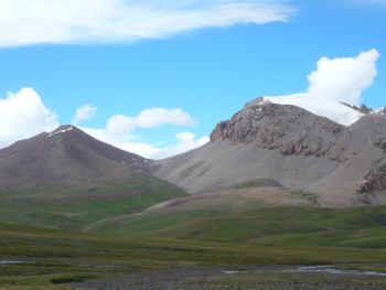
See this picture first, taken from the valley of the Gaoshanxigu looking in a northerly direction. The mountain to the right (east) is Jifu Shan. But the Gaodepu’s source, and so the Mekong’s source, is on the norhteastern face of the mountain to the left. (On this photo that means on the back side of the mountain.)

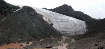
The next two photos are taken in the valley of the Gaodepu looking in a southerly direction. Now Jifu Shan is to our left.

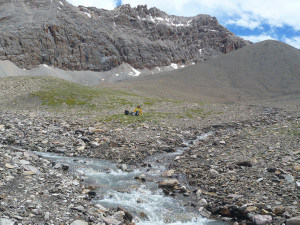
At this confluence the stream from the left is the bigger one. So that is the one we followed when hiking to the source. It turned out that it loops around the hill that can be seen ahead. At no point did we come across a stream from the left, i.e. a stream running down from Jifu Shan, feeding into the Gaodepu.

Behind the hill is the Tibetan ‘marker’ for the river source. But we found that small trickles of water flowed from higher up still. We followed these, and in doing so climbed the mountain to the right in the picture, until we reached the foot of the glacier.This is the source of the Gaodepu and of the Mekong. It is not on Jifu Shan, but on the mountain west of it.

Now to the claims of the ‘father’ of the Jifu Shan source, Dr. Liu Shaochuang. In 1999 he published the location of the Gaodepu’s source and contended it is the Mekong’s source. In ‘Geoinformation Science’, 1999, no. 2, he wrote:

‘The headwaters of Zayaqu are those of the Mekong River. The headwaters are in Jifu Shan 5552m (N33 45 35, E 94 41 12) which is on the boundary of Zhidoi County and Zadoi County. Water supply source to the headwaters is one of snow basins in Zhidoi County.’ (As quoted by Mr. Kitamura in Japanese Alpine News, Vol. 10, 2009).

Then in the March 2007 issue of ‘Geo-spatial Information Science’, page 54, he came up with different coordinates for the Gaodepu’s / Mekong’s source:

‘The Mekong originates from the foot of Mountain Jifu. The geographic position of the source of the Mekong is latitude 33 45 48 N and longitude 94 40 52 E, in which the elevation is 5.200 meter, on the boundary of Zaduo County and Zhiduo County, Qinghai, China.’

The change in coordinates may seem minor. But it means shifting the source from Jifu Shan to the mountain to the west of it. This is easily visible on Google Earth. And it corresponds with  our own observations: the source is on the mountain to the west of Jifu Shan. Our GPS readings for the source: 33 45 677 N and 94 40 562 E. We were using a slightly different ‘decimal’ unit for the last digits, but this is quite close to the 2007 source of Liu. However, our source is located at an altitude of 5.374 meters (GPS measured), so no less than 174 meters higher than Liu’s, at the foot of the glacier where ice melts and starts to flow. So I regard our source on the mountain to the west of Jifu Shan as a more valid Mekong source than Liu’s. It is important to know also that Liu himself has not visited this source west of Jifu Shan, his claim is the result of the study of satellite images.

(By the way, Liu erroneously repeats in 2007 that the source is straddling the boundary between Zaduo and Zhiduo, which is also the divide between the Mekong and the Yangtse basin. Jifu Shan and his original source location are indeed on this divide. But the mountain to the west is not, it is inside the Mekong basin. (See the first photo above.))

Those that favour Guosongmucha above Jifu as the source of the Mekong have come up with  arguments to discredit Jifu. I would like to discredit some of these attempts to discredit.

According to Zhou Changjin and Guan Zhihua the Jifu source is less valid than Guosongmucha because the larger part of Jifu’s glacier is located in the Yangtse basin, a smaller part in the Mekong basin. With the new source west of Jifu, and inside the Mekong basin this becomes an irrelevant remark. Furthermore they ‘accuse’ the Jifu / Gaodepu stream of seasonal changes. However, there is nothing seasonal about the glacial source west of Jifu: it will not run dry at any point of year.

Wong How Man in a newspaper article with dateline Taipei, July 11, 2007 calls Jifu a ‘wetland source’ as opposed to the ‘glacial source’ of Guosongmucha, maybe suggesting a glacial source has to be taken more seriously. As seen however: the source west of Jifu is glacial too, located 400 meters higher than the wetland. In the same article he levels against the Jifu / Gaodepu stream that it is only longer than the Guosongmucha / Gaoshanxigu stream because it does a lot of meandering. The Gaoshanxigu doesn’t, ‘it seemed to be because (it) has a much larger flow thus creating a much larger riverbed and allowing the river to flow in a straight line.’ And he suggests ‘a scenario that if it were to have a smaller flow, the river would meander much more, making it longer.’ First I have to dispute the Gaoshanxigu doesn’t meander because of its larger flow. It doesn’t meander because it is mostly hemmed in by somewhat elevated banks. Second meandering is not only influenced by speed and volume of a water flow, but also by factors as softness of terrain. The meandering of the Gaodepu takes place in a relatively short stretch. After coming down from the mountain it flows rather straight through a rocky river bed, then for a couple of kilometers meanders through soft wetland, then for more than half the distance between source and Yeyongsong confluence flows straight again through a hard rocky bed.

Note that despite everything Wong has to say about the Gaodepu and Jifu Shan, he has visited neither. 

In 2009 two teams announced their intent go on an expedition to the Mekong headwaters. I don’t know if these have indeed taken place. I have found no record of their results. I can’t exclude the possibility they have come up with findings similar to ours. I readily concede of course if anyone shows proof in the shape of photos or GPS tracks they discovered the source on the mountain west of Jifu before we did.

If they do, my tempting thought of having discovered a ‘new’ Mekong source, and even finally the true Mekong source, was to good to be true.

But it will not take away the immense satisfaction of having found this source by ourselves, not by viewing satellite images, but by actually exploring on the ground, following a stream, climbing a mountain and ending up at the foot of a glacier where ice melts and Mekong water starts to flow.

Mekong expedition – July 13

All this week I don’t think of my mother, brother, sister. Not of my father. Not of lovers past and present. Not of friends. Not of  Bach or Rush. Not of favorite books. Not of sports results. Not of  health worries that I am prone to. Not of upcoming trips. I think of nobody, of nothing that constitutes life for me normally. And I am not even aware I don’t think of them.

There is just this focus. Where to put my feet? Enough food in our day packs? When Luciano is ahead making sure I stay close; when I am ahead looking around to see if he stays close. What is the weather going to do? How to stay safe from nomads’ guard dogs? And if not these questions, I feel my feet hurting.

We walk.

We reach the source at Guosongmucha. Located lower than Jifu, and the tributary flowing from here is a bit shorter than the Gaodepu that starts at Jifu. But it is more dramatic, its glaciers are more impressive and more water is running more forceful here.

Mekong expedition – July 12

We walk. We follow the Gaodepu and aim for its head below Mount Jifu: the source of the Mekong.

We make our way through a wetland, finding our footing on hummocks. It isn’t difficult, just tiring after a while.

Further up the ground becomes more solid, consisting of stones and pebbles.

Impatience.

We pass the spot where I turned around last year. After I got home, it seemed on Google Earth to be 140 meters or so away from where the river starts. Indeed a little further on we get to this Tibetan style marker of the Mekong’s source. Source?

Disappointment. No glacier, no spring, no pool where water flows from. Instead the lower part of a rocky slope. Here and there tiny streams can still be seen trickling down between the stones. We move higher up and find a first patch of melting ice, and yet higher up a second patch. Feels more like it. We shoot our source pictures. But now we see the edge of the glacier, high above us still. Luciano hesitates: ‘That is at least another hour’. But I can’t turn around now. We start climbing again. Soon it is my turn to hesitate. I feel uneasy on this steep slope of loose stones, slip a few times.

‘Look for bigger stones and keep walking’, says Luciano. That’s what I do. From then on I am not aware of anything.

I am sitting at the foot of the glacier. I think the final climb has taken me five minutes. I remember nothing. Luciano says it has been about forty, with several short breaks.

My GPS reads N 33.45.677, E 94.40.562, altitude 5.374 meters. This is the highest source of the Mekong at the head of its longest branch.

Joy.

Weather has been good to us today. Hail and rain when we descend, but mild this time. My shoes leak, I didn’t  use them in wet conditions for a year.

Mekongexpeditie – 13 juli

De hele trip denk ik niet aan mijn moeder, broer of zus. Niet aan mijn vader. Niet aan vriendinnen van vroeger of nu. Niet aan andere vrienden. Niet aan Bach of Rush. Niet aan favoriete boeken. Niet aan sportuitslagen. Niet aan kwalen en ziektes waarover ik me makkelijk en nodeloos zorgen maak. Niet aan komende reizen. Ik denk aan niemand, en aan geen van de dingen die normaal mijn leven bepalen. En ik ben me niet eens bewust dat ik daar allemaal niet aan denk.

Alleen maar die focus. Waar zet ik mijn voeten? Genoeg eten in onze dagrugzakken? Raak ik niet ver achterop bij Luciano; of omgekeerd? Wat gaat het weer doen? Hoe houden we ons de waakhonden van de nomaden van het lijf? En wanneer ik me die dingen niet afvraag, voel ik mijn zere voeten.

We lopen.

We bereiken de Mekongbron bij Mount Guosongmucha. Lager gelegen dan de Jifu-bron, en de riviertak die hier begint is korter dan de Gaodepu die ontspringt bij Jifu. Maar hij is dramatischer, de gletsjers zijn indrukwekkender en de waterstroom is groter en veel krachtiger.

Mekongexpeditie – 12 juli

We lopen. We volgen de Gaodepu, ons doel is zijn beginpunt bij Mount Jifu: de bron van de Mekong.

We zoeken onze weg door drassig land, stappen van pol naar pol. Het is niet moeilijk, alleen op den duur vermoeiend.

Verderop krijgen we vastere grond van kiezels en keien onder de voeten.

Ongeduld.

We passeren de plek waar ik vorig jaar omkeerde. Toen ik het later thuis op Google Earth bestudeerde leek dat punt ongeveer 140 meter verwijderd te zijn van het begin van de rivier. Inderdaad markeert wat verder dit Tibetaanse monumentje de bron van de Mekong. Bron?

Teleurstelling. Geen gletsjer, geen bron, geen poel waar water uit weg stroomt. In plaats daarvan het onderste gedeelte van een stenige helling. Hier en daar komen nog minuscule stroompjes tussen de keien naar beneden. We gaan hogerop en komen bij een eerste smeltende ijsveld, en nog hoger bij een tweede. Dat lijkt er meer op. We maken onze bronfoto’s. Maar nu zien we de rand van de gletsjer, nog een stuk boven ons. Luciano aarzelt: ‘Dat is nog minstens een uur’. Maar ik kan nu niet omkeren. We klimmen verder. Dan is het mijn beurt om te aarzelen. Ik voel me zacht gezegd ongemakkelijk op deze steile helling van losse stenen, ik glij een paar keer weg.

‘Stap op de grotere keien en blijf lopen’, zegt Luciano. Dat doe ik.

Dan ben ik me van niets meer bewust.

Ik zit aan de voet van de gletsjer. Ik denk dat ik vijf minuten over de laatste klim heb gedaan. Ik herinner me niets. Luciano zegt dat het er veertig zijn geweest, met een paar korte pauzes.

Mijn GPS geeft aan: N 33.45.677, O 94.40.562, hoogte 5.374 meter. Dit is de hoogste bron van de Mekong, aan het begin van zijn langste tak.

Geluk.

We hadden goed weer. Als we afdalen hagelt en regent het, maar niet hard deze keer. Mijn schoenen lekken, ik had ze al een jaar niet in nat weer gebruikt.

To the source of the Mekong – Three

There are a few nomad tents at the egde of the Zaxiqiwa plain. They were the first people we’d seen in 80 kilometers, and the last I will see in the next 50.

They have a small motorcycle. I have one day left. I see an opportunity to get to the Mekong source at the foot of Jifu Mountain, at the head of its longest tributary. ‘That’s too far, you can’t get there and back in one day. But you have come a long way so we will help you’.

We depart at daybreak. Kelsang drives, I sit behind him. The trail is sometimes sandy, sometimes stony, sometimes it narrows to just a track, sometimes it disappears, sometimes it runs through water. It’s Paris-Dakar in the cold and wet. We make good progress. ‘I may make it’, I think.

But after Yeyongsongdou, the split between the two last main streams of the Mekong, the terrain becomes impassable unless on foot or by horse. Hummocks on swampy soil. Driving between them is impossible: too swampy, too curvy, too narrow. But driving across from one to the other also doesn’t work, for that the gaps between them are too wide. Kelsang keeps trying, but most of the time I walk and get along just as fast.

Halfway along the Gaodepu valley I give up. Another hour and I will have used up half the day’s light already. Driving back in the dark through this deserted world across this terrain is not an option. A fall, injury, wolves…

Here too there are three nomad tents. Inside I rest and warm up. I wonder how all those mountaineers feel that have to turn back, summit already in sight. How I feel myself I don’t know. Numbed? Maybe I look deeply disappointed – the tent owner says he has a bigger bike and suggests we go on.

Moving again. Indeed his bike is a more suitable off the road machine. Time and again we cross the Mekong’s meandering river bed, five meters wide, then four, then three. Then this bike too can’t continue.

I’m left to my own devices now. I walk.

This is where I got:

Naar de oorsprong van de Mekong – Drie

Aan het begin van de Zaxiqiwa vlakte staan een paar nomadententen. Het waren de eerste mensen die we sinds 80 kilometer zagen, en ook de laatste die ik de komende 50 kilometer zal zien.

Ik zie dat ze een kleine motorfiets hebben. Ik heb een dag over. Ik zie een kans om naar de Mekong bron aan de voet van de berg Jifu te gaan, aan het eind van zijn langste tak.

‘Dat is te ver, je kunt niet op een dag heen en weer. Maar je komt van ver dus we zullen je helpen.’

We vertrekken zodra het licht is, Kelsang rijdt, ik zit achterop. Het pad is soms zanderig, soms stenig, soms versmalt het tot een spoor, soms verdwijnt het, soms loopt het door het water. Het is Parijs-Dakar, maar dan nat en koud en op niet veel meer dan een brommer. We maken goede voortgang. ‘Dit kan gaan lukken’, denk ik.

Maar na Yeyongsongdou, de splitsing tussen de twee laatste hoofdstromen van de Mekong, wordt het terrein onbegaanbaar tenzij je te voet of te paard bent. Pollen in een drassige ondergrond. Er tussendoor rijden gaat niet: te drassig, kronkelig, smal. Maar om van pol naar pol te rijden, daarvoor zijn de gaten ertussen dan weer te breed. Kelsang blijft het proberen maar meestal loop ik en dat gaat even snel.

Halverwege het dal van de Gaodepu, tien kilometer van Jifu Shan, geef ik me gewonnen. Nog  een uur en ik heb al de helft van het daglicht opgebruikt. In het donker door dit verlaten gebied over dit terrein terug rijden is geen optie. Valpartij, gewond, wolven…

Er staan weer drie nomadententen hier. Binnen warm ik op en blaas ik uit. Ik vraag me af hoe al die alpinisten zich voelen die om moeten keren, de haven al in zicht. Hoe ik me zelf voel weet ik niet. Verdoofd. Maar misschien zie ik er terneergeslagen uit – de tenteigenaar zegt dat hij een grotere motorfiets heeft en dat we nog wel verder kunnen gaan.

Weer op weg. Inderdaad heeft hij een serieuzere off the road machine. Keer op keer kruisen we de meanderende bedding van de Mekong, vijf meter breed , dan vier, dan drie. Dan kan ook deze motor niet verder.

Ik ben op mezelf aangewezen nu. Ik loop.

Hier kwam ik: