Mekong expedition – July 9

It’s an uncomfortable ride from Yushu to Zaduo. Bumpy and slow, made so by road works. The accompanying encampments and installations are an eyesore on the grasslands. Two high passes are still beautiful but a tunnel is being dug underneath one of them.

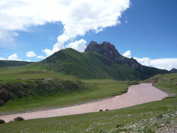
Closer to Zaduo the Mekong, swift and brown-red. Tibetan prayer flags span the river, so do bridges under construction.

Mekong near Zaduo

I meet up with Luciano. He is nearing the end of his eight month walk along the Mekong. We first met on the internet, then in Savannakhet in southern Laos (on the Mekong indeed), and decided to team up to get to the river’s sources.

We meet up with driver Renqing who drove me to Zaxiqiwa last year. That is the most easily accessible source of the Mekong, revered by indigenuous Tibetan nomads for whom this is a spiritual place.

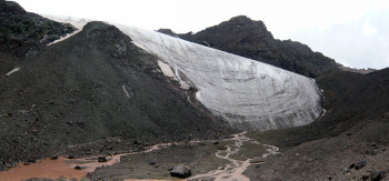
The idea is he will drop us at Zaxiqiwa again. From there we will walk to the Jifu and Guosongmucha sources, about 160 kilometers there and back. Those are higher up and seen as the Mekong’s real sources by the more rationally and scientifically inclined – Chinese, Japanese, westerners.

But we change plan. Renqing says he can get us closer to the sources with his jeep.

It is the bears. Local people warn attacks have occurred, people have died. They simply rip your tent apart. There is no defence. Bears used to stay clear of people when they still carried guns. But the government doesn’t allow that anymore.

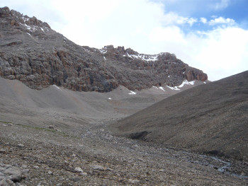
‘Don’t worry about wolves’, they add  reassuringly, ‘they don’t do harm to humans’. They are in wild lands, the Mekong’s headwaters.

No doubt the bear threat exists. No doubt too the threat is exaggerated. But I am the worrying type. So we will travel more by jeep. And whenever possible camp near some of the rare nomad encampments where yaks, guard dogs and more people live, and where bears steer clear of.

Mekong expedition – July 8

3.00 pm

At Xining airport to change planes. 51 hours and counting. Waiting for check-in in the departure hall, waiting to board in the waiting hall, waiting for luggage after the flight was canceled, waiting for a room in the hotel across the parking lot, waiting nèxt day in the departure hall, waiting in the waiting hall, waiting on the plane (we did board this time), waiting for luggage when the flight was canceled after all, waiting in the hotel, waiting in the departure hall, waiting in the waiting hall.

Waiting exhausts.

And all the while uncertainty when I will fly. Ìf I will fly.

And worries about my acclimatisation to altitude. I reasonably adjusted in recent weeks, but how much harm will the delay do?

5.00 pm

My plane takes off.

When we approach Yushu airport we clear sharp grassland peaks,with white pieces of cloud hanging between the green, and the brown-red Mekong floating below, all of it in the perfect glow of late-afternoon sunlight. I hate myself for leaving my camera in my bag in the luggage compartment  across the aisle, out of reach now that we prepare for landing. Amazing Mekong pictures that I can’t take. And the moment is irrepeatable, not a chance ever to see this again like thìs.

Once landed I reconstruct our approach route and imagine a map, and I realize it wasn’t the Mekong, but just the Yangtse. Relief, the missed photo opportunity doesn’t matter much.

The Mekong sources reached

On July 12, 2013, together with Swiss Luciano Lepre, I reached the source of the Mekong at the foot of the glacier of Jifu Mountain, in the emptiest parts of China’s Qinghai province.

The next day we also visited the source at Guosongmucha Mountain, still favored by some as the Mekong’s true source on the grouds that the tributary running from here has a higher water discharge than the river running from Jifu, even though the Jifu source is located higher and its river is longer.

It is tempting to think we are the first ever to have reached both these sources. Expeditions that since the mid 1990’s set out to establish which is the Mekong’s real source very strangely concentrated on either Guosongmucha or Jifu and didn’t bother to visit the other.

I had come close to reaching the Jifu source a year ago, as you can see in previous blog posts. Trickles of Mekong water made their way between stones, pebbles, a first patch of snow. I half counted my source bid, but there was nagging doubt: my gps-track of the trip projected on Google Earth subsequently showed I had been a mere 140 meters away from the start of a snow field that looked like the source. I found out this time it was in fact even another kilometer to the glacier foot, located 250 meter higher. It feels good – make that: very good – I am left with no doubts this time about reaching the Mekong’s source.

 Source of the Mekong, Mount Jifu glacier, my GPS read N 33.45.671,  E 94.40.562, altitude 5.374 meters.

Postscript Later I determined that this highest glacier, where the Mekong starts, is not on Mount Jifu, but on the mountain to its west. The GPS location mentioned is correct.

Mekong villages

South of Luang Phabang scattered on the river’s banks villages hide amid trees and bushes.

Ban Nong Bua Kham is a new settlement, in fact three villages put together. The government made the villagers move down to the river to stop encroachment on the forest. It paid for the removal, it installed electricity, a dirt road connects the village with the outside world. But the people can’t support themselves here. Fishing can’t sustain them, the teak wood grown around the village doesn’t belong to them. And so they keep commuting to their old fields.

Some have disassembled and reassembled their old wooden houses, some could afford new cement blocks and corrugated iron.

Nong Bua  Kham village doesn’t look authentic. Yet its people don’t seem part of this more modern world either. The old still weave bamboo baskets. Rice is still being threshed with a foot-powered pestle and mortar. To the children that foreigner is a strange sight. Some laugh and follow him, though at a safe distance. Some shy away and start crying. And some come to see what’s up first, then after all decide it’s better to start crying.

Had Keo village has Had Keo temple where an old monk serves. In every other aspect too it is the typical traditional ethnic Lao village. Houses on stilts, palm trees, ducks and turkeys, people sitting in the shade. Clean and tidy. In all its simplicity it isn’t poor.

The village of Pak Hao sits, its name literally says so, at the mouth of the Hao. Its white waters splash and crash down between giant boulders. But they are swallowed up by the Mekong, slow and brown here, and in no time no trace is left of them.

And there is the village with the boy under the tree.

A stretch of the Mekong that thus far eluded me

I made the trip to the sources of the Mekong and Yellow River in July, though blogposts here date from September. More ‘live’ from Laos now:

I have traveled along the Mekong in Qinghai and Yunnan; and in the north and south of Laos and in Vietnam; and along the stretch that borders Myanmar; and through the larger part of Cambodia; and I have chalked up many other Mekong ‘sightings’. On the way I have seen glaciers and snow-capped peaks, and low-lying flatlands, forested hills and farmland; I have sailed through a half drowned forest, and along a myriad of streams and canals in the river’s delta.

But the stretch south of Luang Phabang had so far eluded me.

There are no public boats. Upgraded roads make bus travel faster these days. There are no tourist boats either. They stay north of Luang Phabang.

I go to the cargo pier out of town, down a small side road that turns into a mud track, winds through a village – the kind of road that seems to lead nowhere but gives me an ah-great-now-I’m-heading-the-right-way sense.

The man in charge of the port says it shouldn’t be a problem. I should just wait, a couple of cargo boats will leave downstream within a few days. He gives me the mobile numbers of their captains. But a couple of phone calls, a couple of days and a second visit to the pier later it becomes clear that after all it ìs a problem. No captain wants to take me. They say frequent stops to (un)load would make my trip lasting days. I say I don’t care, but they don’t give in. I offer money, they shrug.

Something to hide? Illegal logging? Maybe it ’s just my suspicious mind.

I end up chartering my own boat.

The river mostly moves at some purposeful pace. Once or twice it slows down to a near standstill. Occasionally it rushes through rapids. On the brink of the dry season the water level is still high, but the first rocks start to appear above the surface. It takes a skillful person to manoeuvre between them. The man steering my boat is a professional.

There is hardly any traffic. We see one cargo boat all day, and a few small boats taking people a short distance up- or downstream.

Left and right undulating hills, green everywhere though near the river there is no old growth forest left.

On the banks scattered villages, half hidden amid trees and bushes.

I am as exited as all the other times when I first saw a part of the Great River.

To the source of the Mekong – Three

There are a few nomad tents at the egde of the Zaxiqiwa plain. They were the first people we’d seen in 80 kilometers, and the last I will see in the next 50.

They have a small motorcycle. I have one day left. I see an opportunity to get to the Mekong source at the foot of Jifu Mountain, at the head of its longest tributary. ‘That’s too far, you can’t get there and back in one day. But you have come a long way so we will help you’.

We depart at daybreak. Kelsang drives, I sit behind him. The trail is sometimes sandy, sometimes stony, sometimes it narrows to just a track, sometimes it disappears, sometimes it runs through water. It’s Paris-Dakar in the cold and wet. We make good progress. ‘I may make it’, I think.

But after Yeyongsongdou, the split between the two last main streams of the Mekong, the terrain becomes impassable unless on foot or by horse. Hummocks on swampy soil. Driving between them is impossible: too swampy, too curvy, too narrow. But driving across from one to the other also doesn’t work, for that the gaps between them are too wide. Kelsang keeps trying, but most of the time I walk and get along just as fast.

Halfway along the Gaodepu valley I give up. Another hour and I will have used up half the day’s light already. Driving back in the dark through this deserted world across this terrain is not an option. A fall, injury, wolves…

Here too there are three nomad tents. Inside I rest and warm up. I wonder how all those mountaineers feel that have to turn back, summit already in sight. How I feel myself I don’t know. Numbed? Maybe I look deeply disappointed – the tent owner says he has a bigger bike and suggests we go on.

Moving again. Indeed his bike is a more suitable off the road machine. Time and again we cross the Mekong’s meandering river bed, five meters wide, then four, then three. Then this bike too can’t continue.

I’m left to my own devices now. I walk.

This is where I got:

To the source of the Mekong – Two

We set out from Zaduo again, it’s three days later. Only driver Renqing comes with us this time. He grew up in the Zaxiqiwa area, and he speaks Chinese though Tibetan is his mother tongue. So no need for a guide or interpreter.

He shows little mercy for his Chinese built pick-up truck. Stretches of rough road, potholes, streams – he just pushes on. Once, when ahead the trail gets very muddy, I manage to convince him to take a detour – but that is an exception.

We get to the spot where we got stuck. I want to check first. But he only stops to shift to four-wheel drive mode. He takes a shallower passage. I am sure I feel my feet getting wet. But it’s imagination. We have crossed.

More tributaries of the Mekong follow. Renqing volunteers the name of each of them. We get to the river’s main stream and drive further upstream.

Then the road turns west and leaves the Mekong. So do we.

Marco and Eric are artists who have asked me to facilitate their trip to the origins of the Yellow River and Mekong. We had long discussions: which sources to go to? Several choices are possible, as previous blog posts show. In the end for the Mekong they decided on Zaxiqiwa – the ‘spiritual’ source of the river revered by local Tibetan people. I can’t argue with their artistic decisions of course. But being the more rational type I am disappointed I will not get to the source of my choice, the ‘scientific’ one at the head of the Mekong’s longest tributary, at the foot of Jifu Mountain.

This is why we leave the Mekong’s main stream.

A low pass. Ahead the Zaxiqiwa plain, maybe 15 kilometers across, ringed by hills, dotted with countless silver blue pools. Its green more fresh than any we have seen in the 1,800 kilometers we drove to get here from Xining.

A pang. I am caught off guard. We stop briefly, but the urge to enter this place is stronger than to take in its view. We descend and move across the plain to the Mekong’s Zaxiqiwa source. The sound of birds, the sound of the wind. Brilliant end-of-afternoon light. It’s a moving place to be and one of the purest on earth. The meaning of ‘spiritual source’ dawns on me.

Zaxiqiwa, ‘spiritual’ source of the Mekong

To the source of the Mekong – One

The car fills with the whispered Tibetan prayers of the man from Zaduo. I have asked him to join, none of us knows the way.

The first high mountain pass draws oohs and aahs for its beauty. But we don’t pause, focused as we are on our aim: the Mekong’s source at Zaxiqiwa.

Otherwise we are silent.

The local guide announces ten mountain passes. I soon lose count. Marco doesn’t.

The road winds up and down, right and left. A labyrinth in an empty world.

I make notes, see what my GPS has got to say about our progress.

We approach a river. I jot down it is the biggest stream we have seen so far. When I look up we are in the middle already – and stuck.

Ten centimeters of water soon fill the car. We crawl out through the back, in hopes the water is less deep than left and right perhaps. Or because instinctively people always choose the shortest way to safety. I am sure it looks comical.

Phuntsok has set out without anything one may need: chain or rope for towing, tools, jerrycan, spade, plastic to keep luggage dry. I still bought the latter two – but should have checked better.

After a while a truck. The driver has a rope, we have a cord that ties our luggage together. They wind them together. – that’s clever, I think. It pulls our car out of the river. But it kind of drowned, can’t be brought back to life. The truck moves on, we have to turn back to Zaduo – somehow.

We had gotten halfway.

A tractor shows up. A stroke of good luck. It is in the area because of a grass-sowing program that should prevent soil erosion.

This time there is only our luggage cord to pull our car. It snaps right away.

The tractor goes, comes back much later with a steel cable, tows us up a pass where its driver makes it known he doesn’t have enough gas to tow us any further and takes off. Soon after our guide from Zaduo also leaves in a rare passing car, it has one empty seat.

Darkness falls, we warm some food, pitch tents.

Not so far from each other: the sources of the Yangtse, Yellow River and Mekong

Three of Asia’s longest rivers, the Yangtse (6,300 km), Yellow River (5,500 km) and Mekong (4,900 km) all have their source in China’s Qinghai province, at the northern part of the Tibetan plateau.

Seems like a remarkable fact. But rivers that start furthest inland and at this highest plateau don’t have much choice but to become the longest on their way to the sea.

Besides all three come from Yushu prefecture (the administrative unit below provincial level). And two of them, the Yangtse and Mekong, even come from the same county of Zaduo (the administrative unit below prefectural level).

This if you accept the length of a river’s longest tributary as the criterion to determine a river’s source.

Introduction of satellite measurements has made establishment of river lengths more easy and more reliable. It has led to the ‘relocation’ of the source of all three rivers. The Dang Qu turns out to be a longer tributary of the Yangtse than the Tuotuo He so that its source, traditionally at Geladandong west of Yushu, moves to Zaduo county. The Kari Qu turns out to be longer than the Yueguzong Qu, shifting the Yellow River’s source to the territory of Yushu. The disagreement about the Mekong’s source doesn’t matter in this respect: it will remain in Zaduo county, whatever the outcome.

What’s a river source?

Easy question, right? You’d expect a straightforward answer. But there isn’t.

One who wants to get to the source of a river will instinctively look for the spot that is furthest away from the sea. On a map his finger starts at the mouth and traces the river upstream. He ignores smaller tributaries, at every junction he follows the longest branch. The head of the final branch where he ends up this way, that is his river source.

But some take a different view. Take as an example the dispute on the source of the Mekong that has been going on for the past 15 years. It centers on the two branches of the river that are furthest upstream. Some concerned think that not only their length should be considered to decide which is the source of the Mekong. They argue that their water discharge and the surface area of their basin, among others, should also be taken into account to determine the Mekong’s ‘true’ source. Someone has pointed out that the longest of the two branches meanders a lot, reason why in fact the shortest should maybe be taken more seriously: if it discharges more water more quickly its more forceful stream will prevent it from meandering. The argument has almost been turned upside down: in fact because the one branch is the longest (by way of its meandering) it should nót be assigned as the source.

The outcome of this discussion will bring us what is called the ‘scientific’ source of the river.

Most countries have a geographical or scientific institute that deals with these matters. It is up to that organisation to proclaim A source to be The source. China has two of these institutes.

All of this quite apart from the beliefs of local people. They have been living in a source area for centuries and as long as can be remembered they regard (often: venerate, or even worship) a specific pool, well or beginning stream as the source of the river. The scientists’ criteria are irrelevant to them.

Scientists call this the ‘spiritual’ source.

So whoever wants to get to a river’s source can choose whose lead to follow. The rationally disposed can go along with the scientists, those that feel bureaucrats matter can adhere to the decisions of officialdom, the spiritually inclined can stick with the indigeneous population of the source area.